Mt Agung Volcano Watch 2017
Another day of Mt Agung volcano activity and another update from us on the status of the volcano. Things are starting to happen quickly and there are a few important updates since yesterday. Find yesterdays Update Here
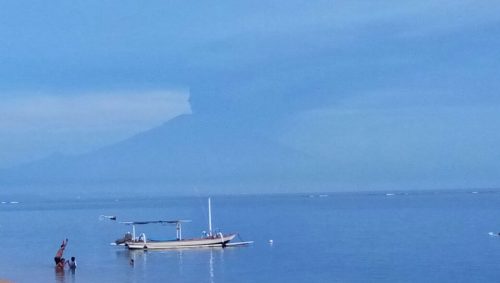
Evening of the 26th of Nov from Sanur Beach
Alert Level of the Volcano
First of all, the Alert Level of the Mt Agung volcano has now gone back to Level 4 (the highest level) from the previous Level 3. Level 4 was the status in September and October when over 100,000 people had to be evacuated from a 12 km radius around the mountain. What does this mean? Well, basically all of the people who had gone back to their homes that were between 6 and 10km have now been asked to evacuate once again. This puts a high level of stress on those people but everyone is evacuating in a calm and efficient manner at this point in time. One interesting difference between now and Sept/Oct is that the mandatory evacuation is now only 10km as opposed to the previous 12km. We are not sure the exact reason for this discrepancy but have just had word that Tulamben is being evacuated so the zone may now have gone to 12km.
Ash Fall
As the volcano is continuously spewing out a large amount of ash due to what is being termed an “effusive eruption”, the direction of the wind is now playing an important role on the effects of the volcano. An effusive eruption is one where the volcano is only blowing out ash and has not entered an “explosive” phase, therefore there is continuous ash pumping out but no major eruption. The information being issued by the authorities is that the crater on top of Agung is now slowly being filled with lava. This can be seen by watching the night time view of the Live View cameras on You Tube and seeing the glowing reflection on the clouds and ash. What is expected in the coming days is for the lava to eventually reach the top of the crater and then slowly seep down the side of the mountain. This is exactly what happened in 1963 with a slowly moving lava flow down the north coast of the mountain that lasted just under a month and traveled 7km with a height of up to 75 metres. This lava flow was on the high slopes of the mountain and did not endanger any population centres.
Now that Bali has been experiencing quite a high amount of ash coming from the volcano for several days, the ash has started to affect the daily lives of the islanders. There is a high amount of ash on the ground in areas close to the volcano itself, and there are reports of lahars forming already. A lahar is a flow of ash mixed with water that goes downhill and basically blankets everything in its path, destroying plant and animal life. So far these lahars are the result of ash on the ground and in the air mixing with a high amount of rain that has fallen in recent days. This means that creek and river beds are being clogged with a cement like mixture instead of water. Lahars of this type are not really dangerous to humans, however, in an explosive event these lahars have the potential to be very destructive. We hope these don’t develop into that status.
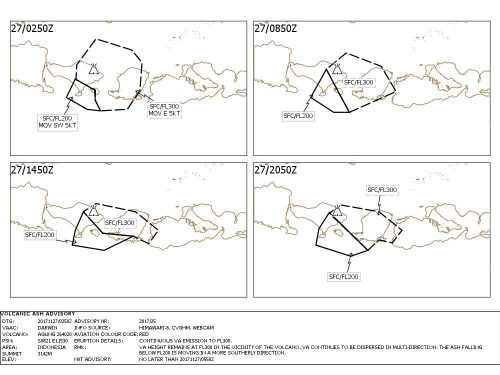
Current track of ash cloud direction for 27th November, note it includes Denpasar and south Bali
Flights and Airport Status
When the ash first started from the Mt Agung volcano, the wind was carrying it in a East – South East direction which was pushing it toward Lombok. This resulted in the closure of the Lombok airport yesterday. However, due to a strong storm developing south of Java, the wind is now starting to push more toward the South South West. What this means is that the ash cloud is now above south Bali, including Denpasar and the Bali International Airport. Unfortunately, this has led to the complete closure of the Bali Airport until further notice. Although several airlines had canceled a few flights on Saturday and Sunday, the airport was still operating normally.
This new development has now led to the stranding of thousands of people who can no longer fly home and the delay of departure dates to anyone trying to get to Bali. There is still the possibility to take a bus/ferry combination to Surabaya on Java, but most people will wait a day or two in Bali before taking that option. Unfortunately there is no way of knowing when the airport will reopen, it could be tomorrow or not until next week. We are at the mercy of the weather for the combination of ash and wind.
Once again some good links: Magma Indonesia, real time updates from the relevant authorities.
Here is the live view of the volcano from nearby in Karangasem, mostly it’s covered by clouds but it’s interesting to see the glow at night.